Ivanhoe’s 2025 exploration program will be the largest on Western Forelands to date, with a budget of $50 million, and a planned 102,000 metres of diamond drilling and 18,000 metres of reverse circulation (RC) drilling.
The Western Forelands’ 2024 drilling program featured over 80,000 metres of diamond drilling. Drilling was predominantly focused on a potential western extension along strike of the Makoko deposit, up to the licence area boundary. Drilling was also aimed at expanding the strike of the adjacent Kitoko discovery.
Drilling confirmed the continuation of mineralization stepping further west from the Makoko area, opening up a new area called “Makoko West”, which revealed shallow and high-grade copper mineralization. As a result, the strike length of the Makoko mineralized district has now increased by 20%, to over 13 kilometres. The total strike length is comparable to that of the Kakula orebody, the main source of copper ore for the Kamoa-Kakula Copper Complex’s Phase 1 and 2 concentrators. The western edge of Kakula’s orebody is approximately 10 km from the eastern edge of the Makoko deposit.
On May 14, 2025, Ivanhoe Mines released an updated interim Mineral Resource on what has become known as the “Makoko Copper District”, which includes the high-grade Makoko, Makoko West, and Kitoko copper discoveries. Mineralization across the Makoko District remains open in multiple directions. Ivanhoe is targeting an additional updated Mineral Resource Estimate in Q2 2026 that will incorporate the remaining 84,000 metres of the 2025 diamond drilling program, of which 66,000 metres are planned across the Makoko District and 18,000 metres are planned on the regional programme, including a 336 km2 package of newly acquired exploration licences located west of Makoko West.

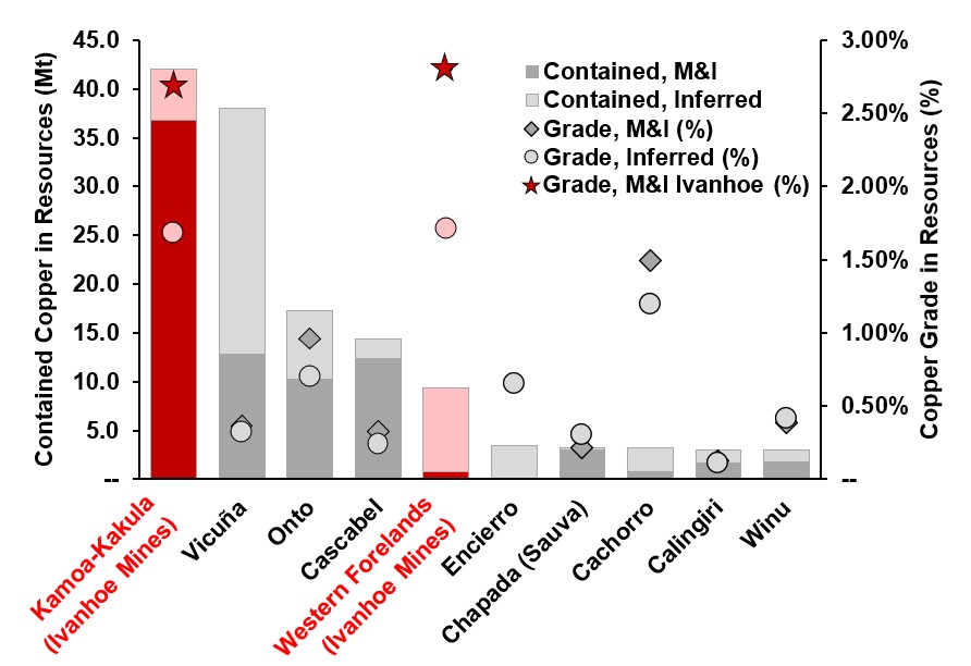
The Makoko District ranks as the world’s highest-grade and fifth-largest copper discovery of the past decade. Ivanhoe’s geologists have discovered a total of 52.5 million tonnes (115.7 billion pounds) of contained copper in the Western Foreland shelf, including Kamoa-Kakula.
Highlights of the interim, updated Mineral Resource estimate for the Makoko District, prepared by Ivanhoe Mines under the direction of the MSA Group (MSA) of Johannesburg, South Africa, in accordance with the 2014 CIM Definition Standards for Mineral Resources and Mineral Reserves:
- Indicated Resources total 27.7 million tonnes at a grade of 2.79% copper, containing 773,000 tonnes (1.7 billion pounds) of copper at a 1% copper cut-off. At a higher 1.5% copper cut-off, Indicated Resources total 25.3 million tonnes at a grade of 2.93% copper, containing 741,000 tonnes (1.6 billion pounds) of copper.
- Inferred Resources total 494 million tonnes at a grade of 1.70% copper, containing 8.38 million tonnes (18.4 billion pounds) of copper, at a 1% copper cut-off. At a higher 1.5% copper cut-off, Inferred Resources total 221 million tonnes at a grade of 2.23% copper, containing 4.93 million tonnes (10.9 billion pounds) of copper.

Makoko District – The world’s fifth-largest and highest-grade copper discovery over the past decade
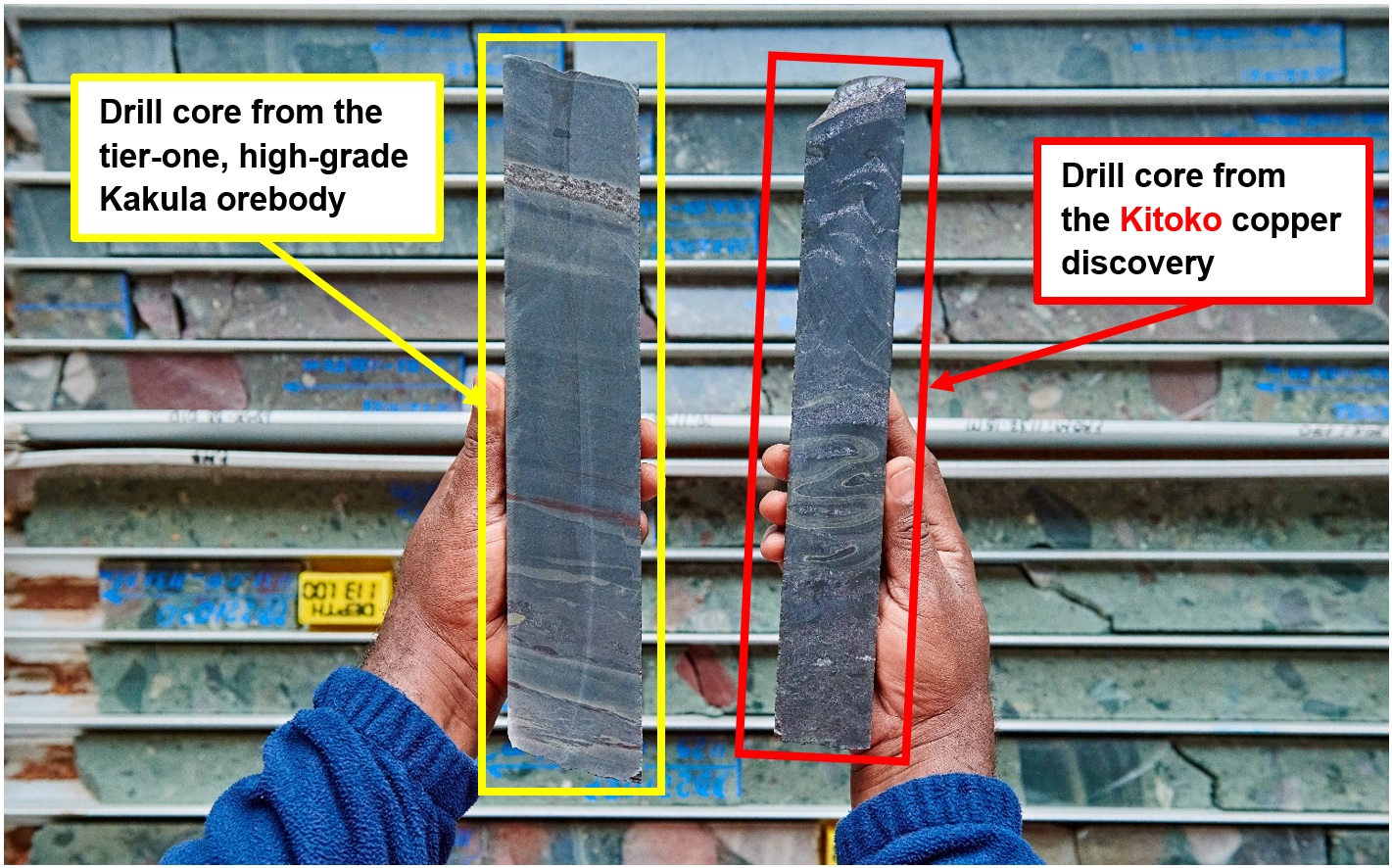
The Makoko discovery was first discovered in 2018 when drilling intersected flat-lying, sedimentary-hosted copper mineralization geologically similar, and at comparable depths to the nearby Kamoa and Kakula orebodies. Subsequent drilling has delineated a continuously mineralized region, now called the Makoko District, joining the three discoveries of Makoko, Makoko West, and Kitoko.
Copper mineralization in the Makoko District currently spans a corridor at least 13 kilometres in length and between 1.7 kilometres and 5.8 kilometres wide. The eastern edge of the Makoko District is situated approximately 10 kilometres from the western edge of Kakula. Mineralization remains open to the northeast and downdip of the current footprint, with a high potential for further resource expansion. There is abundant deposition of copper across the Makoko District, with approximately two-thirds of holes drilled intersecting copper.
The updated Mineral Resource estimate for the Makoko District is based on the results of 147,000 metres drilled in 311 holes, of which 86,000 metres in 123 holes have been added since the maiden Mineral Resource was announced in November 2023. The total area of the updated Mineral Resource has increased by 37.4 square kilometres, with the Indicated Resource covering 1.6 square kilometres and the Inferred Resource covering 57 square kilometres. The average dip of the mineralized zone in the Mineral Resource is between 11 and 18 degrees, dipping to the southeast.
Makoko District Indicated and Inferred Mineral Resources at various cut-off grades.
| Category |
Cut-off Grade
(% Cu) |
Tonnage
(millions) |
Area
(km2) |
Copper Grade
(%) |
Vertical Thickness
(m) |
Contained Copper
(ktonnes) |
Contained Copper
(billion lbs) |
| Indicated |
3.0 |
11.3 |
0.6 |
3.84 |
6.5 |
433 |
1.0 |
| 2.5 |
18.8 |
0.8 |
3.53 |
6.7 |
559 |
1.2 |
| 2.0 |
19.6 |
0.9 |
3.28 |
7.3 |
645 |
1.4 |
| 1.5 |
25.3 |
1.2 |
2.93 |
7.7 |
741 |
1.6 |
| 1.0 |
27.7 |
1.3 |
2.79 |
7.8 |
773 |
1.7 |
| Inferred |
3.0 |
33.4 |
1.6 |
4.29 |
7.4 |
1,430 |
3.2 |
| 2.5 |
46.5 |
2.1 |
3.85 |
7.8 |
1,790 |
3.9 |
| 2.0 |
81.4 |
3.6 |
3.14 |
7.9 |
2,550 |
5.6 |
| 1.5 |
221.2 |
10.4 |
2.23 |
7.6 |
4,930 |
10.9 |
| 1.0 |
493.7 |
25.4 |
1.70 |
7.0 |
8,380 |
18.5 |
Notes:
1. Ivanhoe’s Mineral Resource Manager, Joshua Chitambala, a Professional Natural Scientist (Pr. Sci. Nat) registered with the South African Council for Natural Scientific Professions (SACNASP), estimated the Mineral Resources that were reviewed by Jeremy Witley, Pr.Sci.Nat SACNASP, FGSSA, who is the Qualified Person for the Mineral Resource estimate. The effective date of the estimate is 1 May 2025, and the cut-off date for drill data is 31 December 2024. Mineral Resources are reported using the CIM 2014 Definition Standards for Mineral Resources and Mineral Reserves. Mineral Resources are reported on a 100% basis. Ivanhoe holds an indirect 80% interest in the Makoko SA mining licences, a 100% interest in the Lufupa exploration licences, and a 54% shareholding in the Kampemba mining license.
2. Mineral Resources are reported for Makoko using a total copper (TCu) cut-off grade of 1% TCu and a minimum vertical thickness of 3m. There are reasonable prospects for eventual economic extraction under the following assumptions: copper price $4.00/lb; employment of underground mechanized drift-and-fill mining methods; copper concentrates will be sold to the Kakula smelter or toll treated; average metallurgical recovery is 87.5%; mining costs are assumed to be $38/t; concentrator, tailings treatment, and general and administrative costs are assumed to be $15/t; smelter, refining and transport costs are assumed to be $13.5/t of ore at the cut-off grade; royalty of 3.5%, export tax of 1% and concentrate tax of $100/t NSR concentrate.
3. ICP-MS results have been received for all holes from 2024 that have significant intersections. At the time of estimation, ICP assays for 10 holes of assays not considered to be mineralized were still outstanding.
4. Reported Mineral Resources contain no allowances for hanging wall or footwall contact boundary loss and dilution. No mining recovery has been applied.
5. Approximate drill hole spacings are 400 m to 600 m for Inferred Mineral Resources and 200 m for Indicated Mineral Resources.
6. Rounding as required by reporting guidelines may result in apparent summation differences between tonnes, grade, and contained metal content.

Kiala
Kiala, discovered in 2020, adjoins the northern boundary of the Kamoa-Kakula mining licence and is a northern extension of mineralization from this licence along a north-trending controlling growth structure, where a sulfur-rich siltstone layer is brought progressively closer to, and eventually overlain on the aquifer. This onlapping relationship brings two key mineralizing controls in contact with one another, resulting in a zone of high-grade mineralization parallel to the growth fault.
The Kiala Mineral Resource has been defined by drilling covering an area of 0.9 square kilometres. The average dip of the mineralized zone within the Indicated Resource is nine degrees.
The Mineral Resource estimate is based on the results from approximately 13,000 metres of drilling in 35 holes.
Total Western Forelands’ Indicated and Inferred Mineral Resources estimates, per zone at a 1.0% cut-off grade.
| Category |
Tonnage
(millions) |
Copper Grade
(%) |
Contained Copper
(k tonnes) |
Contained Copper
(billion lbs) |
| Makoko |
| Indicated |
19.6 |
3.10 |
606 |
1.3 |
| Inferred |
319.7 |
1.56 |
4,982 |
11.0 |
| Makoko West |
| Indicated |
8.1 |
2.05 |
167 |
0.4 |
| Inferred |
109.7 |
1.55 |
1,698 |
3.7 |
| Kitoko |
| Indicated |
– |
– |
– |
– |
| Inferred |
64.3 |
2.65 |
1,706 |
3.8 |
| Kiala |
| Indicated |
8 |
2.67 |
212 |
0.5 |
| Inferred |
– |
– |
– |
– |
| Total |
| Indicated |
35.7 |
2.76 |
985 |
2.1 |
| Inferred |
493.7 |
1.70 |
8,386 |
18.5 |
Notes:
1. Ivanhoe’s Mineral Resource Manager, Joshua Chitambala, a Professional Natural Scientist (Pr. Sci. Nat) registered with the South African Council for Natural Scientific Professions (SACNASP), estimated the Mineral Resources that were reviewed by Jeremy Witley, Pr.Sci.Nat SACNASP, FGSSA, who is the Qualified Person for the Mineral Resource estimate. The effective date of the estimate is 1 May 2025, and the cut-off date for drill data is 31 December 2024. Mineral Resources are reported using the CIM 2014 Definition Standards for Mineral Resources and Mineral Reserves. Mineral Resources are reported on a 100% basis. Ivanhoe holds an indirect 80% interest in the Makoko SA mining licences, a 100% interest in the Lufupa exploration licences, and a 54% shareholding in the Kampemba mining license.
2. Mineral Resources are reported for Makoko using a total copper (TCu) cut-off grade of 1% TCu and a minimum vertical thickness of 3m. There are reasonable prospects for eventual economic extraction under the following assumptions: copper price $4.00/lb; employment of underground mechanized drift-and-fill mining methods; copper concentrates will be sold to the Kakula smelter or toll treated; average metallurgical recovery is 87.5%; mining costs are assumed to be $38/t; concentrator, tailings treatment, and general and administrative costs are assumed to be $15/t; smelter, refining and transport costs are assumed to be $13.5/t of ore at the cut-off grade; royalty of 3.5%, export tax of 1% and concentrate tax of $100/t NSR concentrate.
3. ICP-MS results have been received for all holes from 2024 that have significant intersections. At the time of estimation, ICP assays for 10 holes of assays not considered to be mineralized were still outstanding.
4. Reported Mineral Resources contain no allowances for hanging wall or footwall contact boundary loss and dilution. No mining recovery has been applied.
5. Approximate drill hole spacings are 400 m to 600 m for Inferred Mineral Resources and 200 m for Indicated Mineral Resources.
6. Mineral Resources for Kiala were reported in 2023 and have not been changed in this interim update.
7. Rounding as required by reporting guidelines may result in apparent summation differences between tonnes, grade, and contained metal content.
Kitoko – Ivanhoe’s fifth high-grade sedimentary copper discover in the DRC
Kitoko has no surface expression or connection to shallower
mineralization. It was identified through conceptual targeting adjacent to a prominent north-south lineament-fault structure in the airborne magnetics. Mineralization begins at approximately 950 metres and extends down to 1,250 metres depth below surface. High-grade mineralization has been identified in two zones – Kitoko West and Kitoko East – hosted in two sulfur-rich siltstones that pinch out as an onlap against a subtle basement high. These siltstones occur lower in the stratigraphic sequence than those at Makoko and Makoko West.
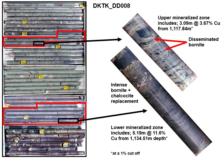
Kitoko East hosts some of the highest-grade drill hole intersections, including 5.2 metres at 11.6% copper from a depth of 1,134 metres. Mineralization at Kitoko East spans approximately 2 kilometres north-south and 1 kilometres east-west and remains open to the south and east. A recent step-out hole, not included in the current resource update (hole KTK048 as shown at the bottom of Figures 3 and 4, as well as on the right of Figure 6), located two kilometres to the south of Kitoko, intersected copper mineralization of a similar nature to that at Kitoko. Definition drilling in 2025 will aim to tighten drill spacing to 400 metres by 400 metres and conduct wide step-outs to test the system’s limits.
Kitoko West is a narrower zone of approximately 500 to 600 metres wide, and appears to be closed off to the west, with weakening mineralization toward the south. Ongoing drilling is testing whether the onlapping siltstone units wrap around the basement high and connect with Kitoko East at depth.
 English
 Français
 日本語
日本語 中文
中文